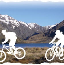
The St James Cycle Trail - the first full Great ride to open on Nga Haerenga, The NZ Cycle Trail, official opening of the St James Cycle Trail.
Saturday 20 November, 10.30am at the Maling Pass entrance car park~35km from Hanmer Springs-just before Lake Tennyson.
Bring your bike to be one of the first to cycle part of this new trail.
For details of the Official Opening, length and times for various cycling options and safety information
Wet weather alternative -St James Homestead
The St James Cycle Trail - the first full Great ride to open on Nga Haerenga, The NZ Cycle Trail
The 66km trail starts and finishes at the Maling Pass and St James Homestead entrances which are 25 km apart along Tophouse Road. Tophouse Road is reached from Hanmer Springs over Jacks Pass to the Clarence River and follows the eastern boundary of St James Conservation Area towards Lake Tennyson.
It is recommended to start the trail at the Maling Pass as there is moe downhill this way. The trail takes 1-2 days depending on your level of fitness and you will need to be fit and experienced to undertake the full trail. You can however cycle parts of the trail starting at either St James Homestead, or the Maling Pass entrance car park.
Programme
10.00am onwards – begin arriving at Maling Pass car park. Tophouse Road.
10.30 am – Official opening
11.00 am – Cyclists / walkers leave Maling Pass car park. Follow the cycle trail as far as you wish with stops at: Sandy Stream, Maling Pass, Waiau River and Lake Guyon. Return the same way.
1.00 pm – First section of cycleway from the car park over Maling Pass to the Waiau River is open for 4WD vehicles.
Choosing your route
Choose your route according to your experience and fitness. The following tracks are all Grade 3 – intermediate level with steep slopes and rough terrain:
-
Sandy Stream (2 km) – 45 min – 1 hour return to car park
-
Maling Pass (a further 4.5 km) – 2 hours return to car park
-
Waiau River – end of 4WD access (a further 6 km) – 4 hours return to car park
-
Lake Guyon (7 more km) – 6–8 hours return to car park
Beyond Lake Guyon turn-off to Edwards Valley the cycle trail becomes more technical and remote, requiring river crossings and bike-carrying in places. This section is Grade 4 – suitable for experienced cyclists. Some cyclists may choose to undertake the whole trail, but will need to be well equipped, fit and experienced.
Track description
The St James Cycle Trail as a whole is designed for experienced mountain bikers looking for a challenge, but there are also intermediate-level sections for those wanting a half- to one-day return ride.
From Maling Pass car park to the pass and over to the Waiau River the track is an old 4WD track. The track may be muddy, rutted and steep in places, meaning bike pushing and even carrying could sometimes be required. Once over the pass it is steeper down to the Waiau River flats where the 4WD access track ends.
The easiest section is from the end of the 4WD track to Lake Guyon. Families can drive over Maling Pass, picnic by the river and enjoy an easy 2–3 hour ride along the river flats and back.
The section after Lake Guyon from the turn-off to Edwards Valley is particularly demanding. Only fit and experienced cyclists should undertake this. In good conditions the whole trail will take 8–10 hours. Check the latest weather forecast, allow plenty of time and be prepared to spend the night out.
Safety information
-
4WD access from Maling Pass car park as far as the Waiau River will be closed to all motorised vehicles until 1pm, Saturday 20 November.
-
Participants are responsible for their own transport to and from event, food and safety.
-
Ensure you have adequate clothing and food and have told someone where you are going and when you plan to return.
-
Note there is no cell phone coverage in this area.
Code of conduct
All mountain-biking tracks are shared-use tracks. This means other recreational users may also be using these tracks, including horse-riders, motorised vehicles, walkers/trampers.
The basic rules for shared-use tracks are:
- Respect that other users have different, and valid, reasons for being there.
- Anticipate other users around corners or in blind spots.
- Expect the unexpected; drive/cycle at a speed you can stop at if a hazard arises.
- Do not startle other users – greet them when approaching.
- The basic give-way rule for shared-use tracks is: 4WD and other motorised vehicles give way to walkers, cyclists and horses; cyclists give way to walkers and horses; and walkers give way to horses. Common sense and courtesy prevail at all times.
Wet weather contingency
If the Maling Pass track is too wet and muddy to cycle, the event will take place at St James Homestead. Participants can cycle the 15-km Peters Loop from the homestead via Peters Valley to Edwards track to Tophouse Road. From here it is an 8-km easy cycle along the shingle road back to St James Homestead.
The opening venue on the day will be marked from Hanmer Springs township.
| Attachment | Size |
|---|---|
| 474.64 KB |